
Web Maps
In the simplest terms, Web Maps is a web-browser utility for plotting data on maps:
Web Maps is interactive and dynamic, with data sourced directly out of EMu or, by utili
Web Maps can be implemented and accessed in two ways:
- A web-based client (perhaps integrated into a website) directly sourcing data from an EMu system or some other web data provider. See How to use the Web Maps interface for details.
- Directly out of an EMu client. In this case Web Maps is generated by running a special report on data directly in the EMu application: this will open a web browser to display Web Maps.
Note: See Web Maps for details.
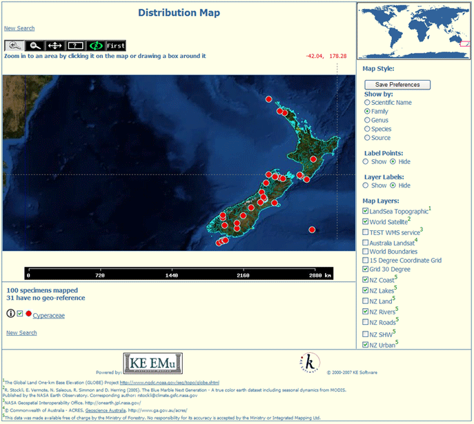
Web Maps comprises various discrete components that display on a web page. Some of the discrete components can be incorporated on their own into other web pages to produce alternative mapping displays. For instance, a page listing search results could include a miniature map of the world overlaid with points that correspond to records displaying on the current page; as the user scrolls through the list the map would update to reflect the distribution of the current record display.
Features of the standard web based Mapping client
Web Maps:
- Can display specimen data held within EMu
-OR-
Using the Portal from one or more EMu and non-EMu sources that implement interfaces such as DiGIR, TAPIR, OAI, etc.
- Automatically generates legends.
- Has interactive panning, zooming, selection of spatial layers, etc.
- Has automatic scale generation and scale dependent layer display (depending on the scale, layers will automatically turn on / off as appropriate).
- Allows map projection to be changed on the fly.
For example, it is possible interactively to change the display to polar stereographic, mercator, geographic projection, etc.
- Can use a multitude of raster and vector data formats for layers, including:
- TIFF/GeoTIFF, EPPL7, and many others via GDAL.
- ESRI shapfiles, ESRI ArcSDE, and many others via OGR.
- Open Geospatial Consortium (OGC) web specifications WMS.
- Allows spatial querying of specimen data against geographic layers.
- Has a highly customi
- Can be implemented and accessed as part of a website or can be generated as a web page directly out of the EMu client.
- Comprises discrete components that can be used to incorporate maps of varying sophistication or features in other web pages.
Note: Please note that Web Maps is licensed separately to EMu.